


 Deuel County, SD
We will offer the following real property at auction “On Site” at the land located from Altamont, SD (Jct. of SD Hwy. #15/476th Ave. & 175th St./Deuel Co. Hwy. #309) – 1 mile north on Hwy. #15/476th Ave. to the SW Corner of FARM #1 and the NW Corner of FARM #2 at the Jct. of 174th St. & Hwy. #15; from Clear Lake, SD (Jct. Hwy. #15 & & 181st St.) – approx. 7 miles north on SD Hwy. #15 to 174th St.; or from Watertown, SD (Exit #177 on I-29) – approx. 11 ½ miles east on Hwy. #212 to Tunerville, then 1 mile south on SD Hwy. #15 (476th Ave.) to 173rd St. – the NW Corner of FARM #1.
ATTENTION – CATTLE PRODUCERS, ROW CROP OPERATORS, HUNTERS & WILDLIFE ENTHUSIASTS! To Be Offered in Multiple Parcels & Combinations of Parcels – All of this Land Is Available to the Buyer for the 2025 Crop & Grazing Season! This auction presents the opportunity to purchase multi-faceted parcels of Deuel County, SD Land with a Mixture of Row Crop Acres & Pasture. These parcels are well located lying adjacent to Hwy. #15 and conveniently located to Clear Lake, SD, Altamont, SD, the Tunerville Corner on Hwy. #212, Watertown, SD and Other Area Points of Interest. These farms have been owned by the Fromm Family for many decades and are now, due to the multi-fractioned ownership of this land by the Fromm children it is being offered for sale at public auction, presenting a once in a lifetime opportunity to purchase this land. If you are in the market for Deuel County, SD land, then make plans to inspect these farms and be in attendance at this Auction! SPECIAL NOTE – All of This Land is Available for the Use of the Buyer for the 2025 Crop & Grazing Season, with immediate possession on sale day!
LAND AUCTION
803.24+/- Surveyed acres of well located Altamont Township, Deuel County, SD Land – Inclusive of a mixture of cropland, CRP & pasture
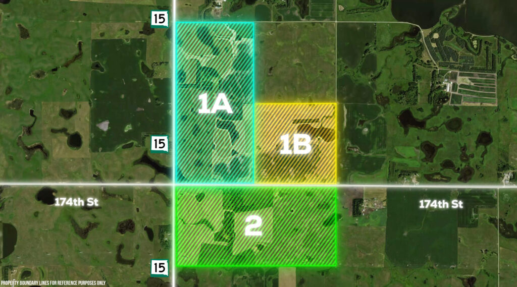
These +/- 803.24 Surveyed Acres will be Offered as – FARM #1 – +/-481.16 Surveyed Acres with Remnants of a Former Farmstead with a Well (Not in Use) with a Mixture of Cropland, Pasture & Areas with Some Hunting & Wildlife Habitat – To be Offered as PARCEL #1A (The W ½ of Sec. 11) – +/-320.41 Acres w/Remnants of a Farmstead, Cropland, CRP & Pasture; PARCEL #1B – (The SE ¼ of Sec. 11) – +/-160.75 Acres of Cropland & Pasture or as Parcels #1A & 1B Combined – +/-481.16 Acres – Both Located in Sec. 11; and FARM #2- +/-322.08 Surveyed Acres in Sec. 14; or as FARMS #1 & #2 Combined – The Entire +/- 803.24 Surveyed Acres – Which is a Combination of Both Farms #1 & #2 in Their Entirety.
FARM #1: +/-481.16 Surveyed Acres – Legal Desc.: Parcel #1A – +/-320.41 Acres – The W ½ of Sec. 11, T. 116N., R. 49W.; Parcel 1B – 160.75 Acres – The SE ¼ of Sec. 11, T. 116N., R. 49W.; all in Altamont Twp., Deuel County, SD.
FARM #1 will be offered as PARCEL #1A – The W½ of Sec. 11 comprised of +/-320.41 Surveyed Acres; PARCEL #1B – The SE¼ comprised of +/-160.75 Surveyed Acres; or as PARCELS #1A & #1B Combined – The +/-481.16 Surveyed Acres as a Unit. Parcel #1A is a +/-320.41 Acre Surveyed Parcel in the W½ of Sec. 11 which includes remnants of a former farmstead being inclusive of a barn, a well that is presently not in use, trees and other incidental improvements, along with a mixture of cropland, CRP and pasture; Parcel 1B is a +/-160.75 Acre Surveyed Parcel in the SE¼ of Sec. 11 and is comprised of a mixture of cropland and pasture/hayland. According to FSA information FARM #1 as a whole is identified as Tract #610 and is indicated to have approximately 190.16 acres considered as cropland, of which approx. 69.04 acres is enrolled in CRP (all of the CRP being in the W½ of Sec. 11 or Parcel #1A), leaving approx. 121.12 acres of effective cropland subsequent to the reduction of the CRP acres, with a 51.50 acre corn base with a 149 bu. PLC yield, a 40.96 acre wheat base with a 58 bu. PLC yield, a 12.60 acre soybean base with a 42 bu. PLC yield, a 5.60 acre barley base with a 39 bu. PLC yield and a 4.70 acre oats base with a 51 bu. PLC yield. The CRP is currently under 2 contracts – Contract #11262B has 63.24 acres enrolled at $130.28 per acres generating a total annual payment of $8,239.00 and is scheduled to expire on 9/30/2034; Contract #11422A has 5.80 acres enrolled at $189.21 per acre generating a total annual payment of $1,097.00 and is scheduled to expire on 9/30/2031. This farm either as individual parcels or as a whole is extremely well suited for us in conjunction with a diversified row crop and cattle operation, furthermore with the existing CRP acres, trees and other attributes Parcel #1A affords some excellent hunting opportunities. This property is subject to a combination of US Fish & Wildlife Wetland Easements, with the S½ of Section 11 being subject to a Wetland Easement – which allows for row cropping or grazing at any time, although prohibiting filling, burning or draining of any of the designated wetland areas; In addition there are two areas containing a total of 190 acres that are also subject to a perpetual US Fish & Wildlife Grassland Easement – these areas include approx. 90 acres including the W½ SW¼ (+/-80 Acres) and the adjacent area lying directly north in the S½ S½ SW¼ NW¼ (+/-10 Acres), as well as an additional 100 acres in the N½ SE¼ and the E½ SE¼ SE¼. According to a review of the FSA aerial map it appears that Fields #17 and #18 together consist of approx. 230 acres of pasture. Livestock water in the pasture is provided by a combination of stock dams/dugouts, ponds and seasonal waterways. Rural Water is located on the W. side of Hwy. #15 & the N. side of 173rd St. According to information obtained from Surety Agri Data, Inc. – FARM #1 as a whole has a soil index of 62.8; while individually Parcel #1A has a soil rating of 64.3 and Parcel 1B has a soil rating of 59.8. This land has topography which is generally gently rolling. There also is an existing Wind Easement on the property with Southern Power Company on +/-478 acres in Sec. 11 which currently is paying approx. $15.00 per acre which will be prorated in accordance with calculations as determined by Southern Power and Debra Fromm of the Fromm Family and thereafter assigned and a succession agreement executed between Southern Power and the buyer. The 2024 RE Taxes payable in 2025 on this property on Parcel #1A (W ½ of 11-116-49) are $3,894.62 and on Parcel #1B (SE ¼ 11-116-49) are $1,693.94.
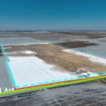
FARM #2 – +/-322.08 Surveyed Acres of Hayland & Pasture – Legal Desc.: The N½ of Sec. 14, T. 116N., R. 49W., (Altamont Twp.), Deuel County, SD. – With the Northwest Corner of FARM #2 located from the Jct. of SD Hwy #15/476th Ave. and 174th St. – approx. 1 mile north of Altamont, SD.
FARM #2 is an excellent parcel of East River SD pasture/hayland, that is especially well suited for the cow-calf producer. This parcel appears to have a combination of native and tame grass, with water provided by a combination of stock dams/dugouts, ponds and seasonal waterways. There is an existing Brookings-Deuel RWS Rural Water Line which runs across the West side of Farm #2. Within this parcel, the FSA aerial photo shows 5 fields that at some point may have been utilized as cropland, although none of this land can be row cropped as the entire property is under a combination of perpetual US Fish & Wildlife Grassland and Wetland Easements and as such is essentially permanent pasture with row cropping of any portion prohibited. The perpetual grassland easement prohibits tillage on the land, but allows unrestricted grazing and haying after July 15th in accordance with the term of the easement. According to information obtained from Surety Agri Data, Inc. – FARM #2 has a soil rating of 57.1. This land has topography which is generally gently rolling to rolling. There are no wind easements in place on this property. In addition to the pasture and grazing opportunities, this parcel may have some added hunting prospects. The 2024 RE Taxes payable in 2025 on this property (N ½ 14-116-49) are $3,259.16.
FARM #1 will be offered as PARCEL #1A – The W½ of Sec. 11 comprised of +/-320.41 Surveyed Acres; PARCEL #1B – The SE¼ comprised of +/-160.75 Surveyed Acres; or as PARCELS #1A & #1B Combined – The +/-481.16 Surveyed Acres as a Unit & FARM #2 – +/-322.08 Surveyed Acres of Hayland & Pasture – Legal Desc.: The N½ of Sec. 14, T. 116N., R. 49W., (Altamont Twp.), Deuel County, SD. – With the Northwest Corner of FARM #2 located from the Jct. of SD Hwy #15/476th Ave. and 174th St. – approx. 1 mile north of Altamont, SD.
Cash – A 10% non-refundable downpayment with immediate possession of the land on the day of the sale, with the balance due and payable on or before May 7, 2025 with full possession for the 2025 crop and grazing season. All of this land is subject to a US Fish and Wildlife Wetland Easement, furthermore Portions of FARM #1 and ALL of FARM #2 are also being subject to Perpetual Grassland Easements. There is an existing Wind Lease and Easement Agreement in place on this parcels situated in Section 11 (FARM #1 – Parcels #1A & #1B) with Invenergy Wind Development, LLC/Southern Power Company, which was executed in 2016 with the sellers to retain any and all payments attributable to 2024 and paid in arrears in 2025, and also for a portion of 2025 for the period from January 1, 2025 to the date of closing – which currently pays approx. $15.00 per acre, with actual payments to be prorated in accordance with a percentage of the acres outlined in that contract, furthermore there presently are NO towers in place on the property, although provisions of the easement prescribe compensation for construction of each wind tower and a per megawatt amount subsequent to construction, as well as other compensation as prescribed within the agreement, with the buyer to be bound to the length and terms of the Wind Lease and Easement Agreement. Subsequent to closing the new purchaser will be obligated to provide deeds/documents to Southern Power for assignment of the seller’s rights to the respective purchasers in order to receive subsequent payments in 2026 and thereafter for the remaining term of the contract which appears to be scheduled to run for the initial term of 30 years from the effective date in 2016 and through Feb. 2046 with extension options thereafter until Feb. 2066. There are no existing wind easements on Farm #2 (the land in Sec. 14) Marketable Title will be conveyed and an owner’s title insurance policy will be provided with the cost of the owner’s policy and closing agents fee to be divided 50-50 between the buyer and seller. All of the RE taxes for 2024 payable in 2025 will be paid by the sellers, with the buyer to be responsible for 100% of the 2025 RE taxes payable in 2026. The acres in these properties are based on the acres as determined by a survey as completed by Midwest Land Surveying, Inc., with the acres to be understood to be “more or less”. The sellers do not guarantee that the existing fences lie on the true and correct boundary and any new fencing with be the responsibility of the purchaser pursuant to SD Law. Information contained herein is deemed to be correct but is not guaranteed. This property is sold in “AS IS Condition” and is sold subject to existing easements, restrictions, reservations or highways of record, if any, as well as any or all applicable zoning ordinances. The RE licensees in this transaction stipulate that they are acting as agents for the sellers. Sold subject to confirmation of the owners. To make arrangements for Online Bidding or for absentee phone bidding contact the auctioneers.
HEIRS OF HOWARD & SANDRA FROMM – dba Fromm Property Holdings, LLLP
Chuck & Jared Sutton CAI Auctioneer & Land Broker, Sioux Falls, SD ph. 605-336-6315 & Flandreau, SD, ph. 605-997-3777 & 605-864-8527 Burlage Peterson Auctioneers & Realtors, LLC Land Brokers - Auctioneers - Realtors - Farm Managers Office@burlagepeterson.com or 605-692-7102 317 4th St., Brookings SD, 57006
 148.43 +/- Acre Land Auction, Hamlin Co., SD
Scroll to top
148.43 +/- Acre Land Auction, Hamlin Co., SD
Scroll to top